Site Overview
Country
GR
Latitude (°)
37.67306
Longitude (°)
21.44158
Altitude (m)
Code
???
Owner
SDGEE_AUTH
Instrumentation
Permanent
StationID
PYR1
LocationID
00
Network
HI
Sensor alt. (m)
Bldg/Shelter Desc.
Basement of a 2-st R/C (A.T.E. BANK)
Morphology
Topography Scheme A
T1
Topography Scheme B
Surface Geology
Sequence of fine sands, sandy, silty clayey deposits, and rare pebbles and clay rubbles: predominant type in the Pliocene sedimentary sequence is brownish-yellow, fine to middle-grained calcareous sands
Map Scale
1:50,000
Geology Ref.
IGME, Geological Maps of Greece
OneGeology
H800 Depth (m)
Seism. Bedrock Depth (m)
85
EC8 Class
C
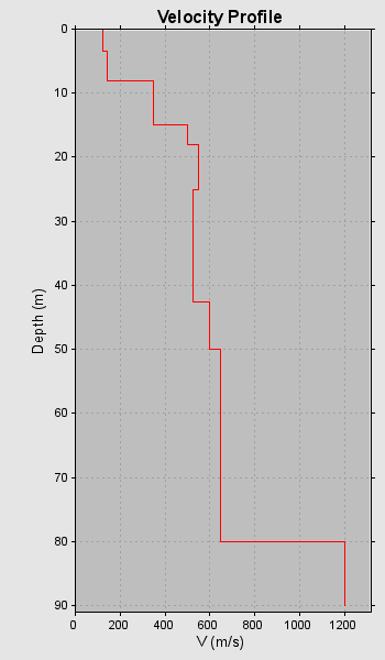
VS30 (m/s)
276
VS30 Method
Crosshole
VS30 Index
3.5
VS30 Ref.
O.A.S.P. 8048
f0 (Hz)
1.547
f0 Method
Inferred
f0 Index
2.0
f0 Ref.
Pitilakis et al. (2013)
VS Profiles
1
VP Profiles
0
QS Profiles
0
QP Profiles
0
Borehole Profiles
1
CPT Profiles
0
2nd Level Data
- Short Reference
- O.A.S.P. 8048
- Method
- Crosshole
- Datafile
Preferred profile
- Short Reference
- N/A
- Latitude (°)
- 0.0
- Longtude (°)
- 0.0
- Total Drilling Depth (m)
- N/A
- Bedrock Depth (m)
- N/A
- Ground Level (m)
- N/A
- Ground Water Measured (m)
- N/A
- Investigation Information
- N/A
- Original Reference
- N/A
- Documents
- N/A
- End Date
- N/A
- Graphical Log
- No
- Status
- N/A
- Datafile
Preferred profile