Site Overview
Country
GR
Latitude (°)
40.634
Longitude (°)
22.94
Altitude (m)
Code
???
Owner
SDGEE_AUTH
Instrumentation
Permanent
StationID
THE6
LocationID
00
Network
HI
Sensor alt. (m)
Bldg/Shelter Desc.
Basement of a 8-st R/C (City Hotel)
Morphology
Topography Scheme A
T1
Topography Scheme B
Surface Geology
Holocene deposits undivided: coastal deposits (sand, gravel), valley deposits, red clay with calcareous concretionary bodies; at the base, the conglomerates dominate
Map Scale
1:50,000
Geology Ref.
IGME, Geological Maps of Greece
OneGeology
H800 Depth (m)
Seism. Bedrock Depth (m)
100
EC8 Class
C
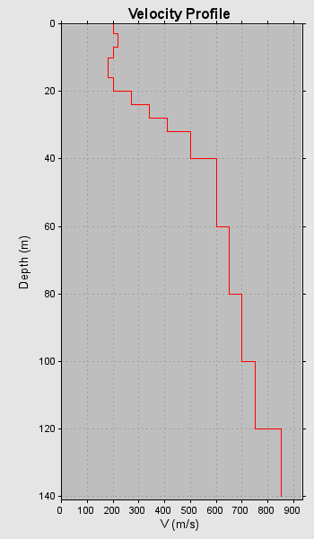
VS30 (m/s)
226
VS30 Method
VS30 Index
0.2
VS30 Ref.
O.A.S.P. 8048
f0 (Hz)
1.059
f0 Method
Inferred
f0 Index
2.0
f0 Ref.
Pitilakis et al. (2013)
VS Profiles
1
VP Profiles
0
QS Profiles
0
QP Profiles
0
Borehole Profiles
0
CPT Profiles
0
2nd Level Data
- Short Reference
- O.A.S.P. 8048
- Method
- N/A
- Datafile
Preferred profile