Site Overview
Country
GR
Latitude (°)
37.03918
Longitude (°)
22.11076
Altitude (m)
27.0
Code
???
Owner
SDGEE_AUTH
Instrumentation
Permanent
StationID
KALA
LocationID
00
Network
HL
Sensor alt. (m)
Bldg/Shelter Desc.
Basement of a 3-st R/C (O.T.E.)
Morphology
Topography Scheme A
T1
Topography Scheme B
Surface Geology
Alluvial deposits: mainly rounded pebbles, gravels, and locally sandy clays
Map Scale
1:50,000
Geology Ref.
IGME, Geological Maps of Greece
OneGeology
H800 Depth (m)
Seism. Bedrock Depth (m)
80
EC8 Class
B
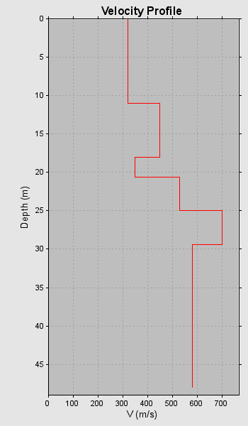
VS30 (m/s)
410
VS30 Method
Crosshole
VS30 Index
3.5
VS30 Ref.
O.A.S.P. 8048
f0 (Hz)
2.48
f0 Method
Inferred
f0 Index
2.0
f0 Ref.
Pitilakis et al. (2013)
VS Profiles
1
VP Profiles
0
QS Profiles
0
QP Profiles
0
Borehole Profiles
0
CPT Profiles
0
2nd Level Data
- Short Reference
- O.A.S.P. 8048
- Method
- Crosshole
- Datafile
Preferred profile