Site Overview
Country
GR
Latitude (°)
38.00397
Longitude (°)
23.71033
Altitude (m)
50.0
Code
???
Owner
SDGEE_AUTH
Instrumentation
Temporary
StationID
SPLB
LocationID
00
Network
HL
Sensor alt. (m)
Bldg/Shelter Desc.
Basement of a 3-st R/C (Subway Garage)
Morphology
Topography Scheme A
T1
Topography Scheme B
Surface Geology
cemented conglomerate / 17-22.5m sandy siltstone / 22.5-24m calcareous siltstone
Map Scale
1:50,000
Geology Ref.
Novak et al. (1999) (1999)
OneGeology
H800 Depth (m)
Seism. Bedrock Depth (m)
21
EC8 Class
B
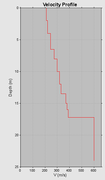
VS30 (m/s)
362
VS30 Method
SPT
VS30 Index
1.6
VS30 Ref.
Bouckovalas et al. (2001)
f0 (Hz)
f0 Method
f0 Index
0.0
f0 Ref.
VS Profiles
1
VP Profiles
0
QS Profiles
0
QP Profiles
0
Borehole Profiles
0
CPT Profiles
0
2nd Level Data
- Short Reference
- Novak et al. (1999) (1999)
- Method
- SPT
- Datafile
Preferred profile